
Magnolia Livable Centers Study
In partnership with our region’s Metropolitan Planning Organization, the Houston-Galveston Area Council (H-GAC), Fort Bend County Precinct 2 applied for and was awarded funding to conduct a Livable Centers Study in the Fresno area. The objectives of the Livable Centers Program are to reimagine auto-focused infrastructure, policies, and programs aiming to create mixed-use places that provide multi-modal transportation options, improve environmental quality, improve pedestrian safety, and promote economic development and housing diversity.
H-GAC’s Livable Centers Program teams work with local communities to identify context sensitive recommendations, a vision for the study area, and an implementation plan that will provide the community leaders with the resources they need to facilitate Livable Centers.
Livable Centers are places where people can live, work, and play with less reliance on their cars. They encourage a complementary mix of land uses that are designed to be walkable, connected, and accessible by multiple modes of transportation.
Overview
The City of Magnolia, like many cities in the Houston-Galveston MSA, sits within a rapidly growing corridor shaped by recent regional thoroughfare expansions. Magnolia’s charm lies in its small-town atmosphere, which increasingly conflicts with the demands of rapid growth. Its car-oriented transportation network does not meet the needs of residents. The lack of sidewalks, narrow streets, and railroad crossings makes all modes of travel challenging. Poor neighborhood connectivity has created isolated pockets accessible only by car, contributing to rising auto-pedestrian accidents and limiting access to education, employment, and essential services. These gaps not only deepen social inequities and hinder economic potential, they also leave the city less prepared to respond to emergencies. Magnolia’s vulnerability to flooding and wildfires underscores the need for a more connected, resilient transportation network that can support both daily mobility and critical emergency response efforts.
The Livable Centers Study represents Magnolia’s commitment to a community-driven vision that enhances infrastructure while preserving its small-town identity. The Study will outline strategies to reduce car dependency by expanding pedestrian and bicycle infrastructure, improve local sense of place through inclusive public space design, and help the City plan proactively for future growth.
Study Area
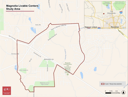
Once the center of town, the study area has seen economic decline and abandonment due to the widening of FM 1774 /FM 1488 over the past five years. With FM 1774 complete, and FM 1488 nearing completion, the area is poised for re-development. The study area is bounded by FM 1488 to the north, Magnolia Junior high school and FM 1774 to the south, Magnolia Ridge Blvd. to the east, and Unity Park Dr. to Magnolia Business Park Dr to the west.
The area features local businesses, 4 schools (enrollment of ~3,500 students), parks, retails hubs, a business park and community facilities. The northeast quadrant, bordered by FM 1488, Magnolia Blvd, and Magnolia Ridge Blvd, is set for a significant development. The planned development is a 200-acre project mixed-use Town Center featuring hotel, civic space, over 55 housing, retail mixed-use and medical office hub. The study area is strategically selected to align with current and future economic drivers, ensuring that the enhancements proposed will benefit Magnolia’s evolving community.